
If Mother Nature made a to-do list for Texas, we’d venture to guess that these hikes would be on it. They capture much of what the Lone Star State’s wild backyard has to offer. Breathtaking mountain vistas? Check. Splendid canyons? Check. Deep forests and swampy lowlands? Check and check.
This list is designed to inspire. Consider the hikes below as an invitation to explore the state’s rugged wonderland.
Recommended Videos
Hike smart. Keep these safety tips in mind when preparing for your hike.
🎵 Texas road trip playlist: Sing your way across the state, from ‘Galveston, oh Galveston’ to the ‘West Texas Town of El Paso’
Summit Trail, Enchanted Rock State Natural Area
Every Texan should climb to the top of this popular pink granite dome in the Hill Country at least once.
Distance: 0.6 miles one-way
Difficulty: Strenuous
Elevation gain: 425 feet
Hiking time: One hour
Management: Texas Parks & Wildlife Department
Map: Download the Enchanted Rock State Natural Area Trails Map (PDF)
Information: Enchanted Rock State Natural Area, 16710 RR 965, Fredericksburg, TX 78624; (830) 685-3636; tpwd.texas.gov/state-parks/enchanted-rock
Lighthouse Trail, Palo Duro Canyon State Park
The Lighthouse Trail leads hikers to Lighthouse Peak, the most popular formation in Palo Duro Canyon. Designated a Natural National Landmark, the stunning 310-foot hoodoo was formed by water and wind erosion and vaguely resembles any number of towering objects, including -- yes, you got it -- a lighthouse. The trail to the lighthouse is well established. It’s quite wide and there are markers nearly every tenth of a mile. The trail does cross several arroyos where water may be present. A note of caution: the final leg of the trail is rather steep, but the rewards are great.
Distance: 2.8 miles one-way
Difficulty: Moderate
Elevation gain: 308 feet
Hiking time: Two hours
Management: Texas Parks & Wildlife Department
Map: Download the Palo Duro Canyon State Park Trails Map (PDF)
Information: Palo Duro Canyon State Park, 11450 State Hwy Park Rd 5, Canyon, TX 79015; (806) 488-2227; tpwd.texas.gov/state-parks/palo-duro-canyon
Guadalupe Peak Trail, Guadalupe Mountains National Park
At 8,749 feet in elevation, Guadalupe peak is the highest point in the state. Naturally, the views from the “top of Texas” are phenomenal, well-worth the arduous, 4.2-mile ascent to the summit. Expect the journey to challenge you from the get-go. You will encounter the steepest part of the hike in the first mile and a half, as the trail switchbacks up a steep slope (Wear hiking boots if you don’t want to roll ankles). Whenever you stop to catch your breath -- you will do this a number of times -- marvel at the remarkable views. They will get better every switchback you climb. They will prove a crucial source of motivation. As the trail flattens, you’ll encounter a small forest of pinion pine, and later, a sparser forest of ponderosa pine. Then, the trail descends slightly and crosses a wooden bridge. During the final climb to the summit, you’ll see breathtaking views of the top of El Capitan to your south. Eventually, you’ll arrive at the summit, where you’ll find a commemorative spire mounted at one of the peak’s high points.
Distance: 4.2 miles on-way
Difficulty: Strenuous
Elevation gain: 2,927 feet
Hiking time: Four hours
Management: National Park Service
Map: Download the Guadalupe Mountains National Park Trails Map (PDF)
Information: Guadalupe Mountains National Park, Pine Springs Visitor Center, 400 Pine Canyon Road, Salt Flat, TX 79847; (915) 828-3251; www.nps.gov/gumo
Window Trail, Big Bend National Park
Hiking the Window Trail is a classic Big Bend experience and a must-do hike offering dramatic views of some of the major peaks in the Chisos range. This trail descends through a canyon to the trail’s namesake Window, a pour-off which frames panoramic desert vistas. Use caution on this trail: the top of the Window pour-off is slick rock with no railings. Step too close to the edge of the Window and risk a 220-foot freefall. It’s a breezy, downhill walk to the Window, but the return trip is a challenging climb of 900 feet.
Distance: 2.25 miles one-way
Difficulty: Moderate
Elevation change: 900 feet
Hiking time: Two hours
Management: National Park Service
Map: Download the Big Bend Park Brochure Map (JPEG)
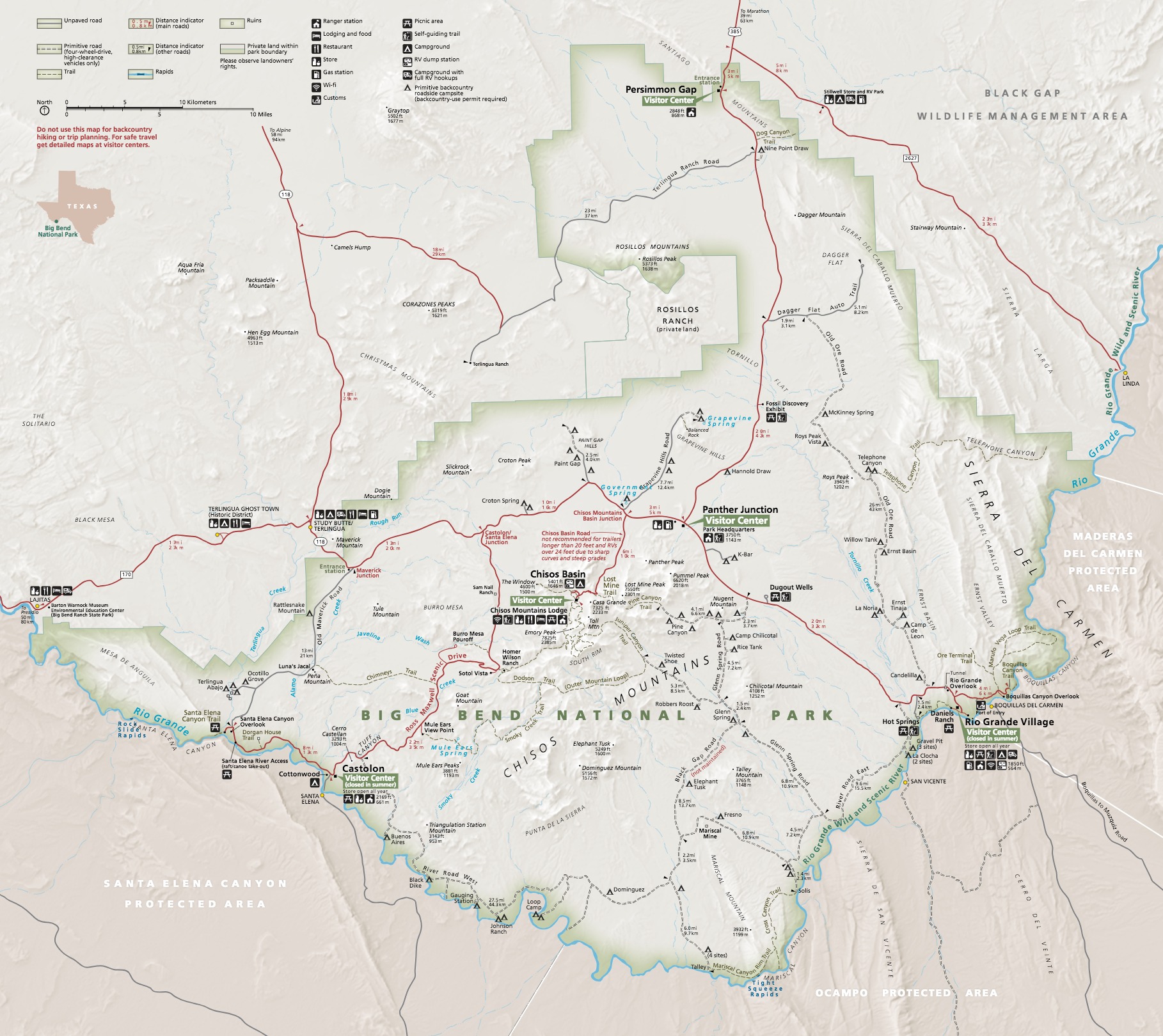
Information: Big Bend National Park, Panther Junction Visitor Center, 310 Alsate Dr., Big Bend National Park, TX 79834; (432) 477-2251; www.nps.gov/bibe
Lost Mine Trail, Big Bend National Park
Park staff and visitors often list this trail as their favorite hike in Big Bend National Park. Rising 1,100 feet over 2.4 miles (4.8 miles round-trip), the Lost Mine Trail offers some of the best scenic views in the park.
Distance: 2.4 miles one-way
Difficulty: Strenuous
Elevation gain: 1,100 feet
Hiking time: Two hours
Management: National Park Service
Map: Download the Big Bend Park Brochure Map (JPEG)
Information: Big Bend National Park, Panther Junction Visitor Center, 310 Alsate Dr., Big Bend National Park, TX 79834; (432) 477-2251; www.nps.gov/bibe
Upper Canyon Trail, Caprock Canyons State Park & Trailway
Gain and lose hundreds of feet in elevation hiking this trail through red earth country.
Distance: 7.5-mile loop
Difficulty: Strenuous
Hiking time: Six hours
Management: Texas Parks & Wildlife Department
Map: Download the Caprock Canyons State Park Trails Map (PDF)
Information: Caprock Canyons State Park & Trailway, 850 Caprock Canyon Rd., Quitaque, TX 79255; (806) 455-1492; tpwd.texas.gov/state-parks/caprock-canyons
East Trail, Lost Maples State Natural Area
Admiring the fall foliage at Lost Maples is another requisite Texas experience. On the park’s East Trail, you’ll discover bigtooth maples, bald cypress and sycamores as you hike along the spring-fed Sabinal River. As you ascend rocky slopes, you’ll be rewarded with spectacular views. Expect to find a diversity of wildlife on this beautiful trail.
Distance: 3.1 miles one-way
Difficulty: Challenging
Hiking time: 3 hours
Management: Texas Parks & Wildlife Department
Map: Download the Lost Maples State Natural Area Trails Map (PDF)
Information: Lost Maples State Natural Area, 37221 F.M. 187, Vanderpool, TX 78885; (830) 966-3413; tpwd.texas.gov/state-parks/lost-maples
Kirby Nature Trail, Big Thicket National Preserve
Experience the biodiversity of the Big Thicket on this trail offering views of old cypress trees, swampy baygalls, dense forest, and the tranquil waters of Village Creek.
Distance: 1.5 to 2.5 miles roundtrip
Difficulty: Easy
Management: National Park Service
Map: Download the Kirby Nature Trail Map (PDF)
Information: Big Thicket National Preserve, FM 420, Kountze, TX 77625; (409) 951-6700; nps.gov/bith
40-Acre Lake Trail, Brazos Bend State Park
This trail is an excellent way to view a plethora wildlife, including the American Alligator. Along the way, climb the four-story observation tower to get a bird’s eye view of the park.
Distance: 1.2 mile loop
Difficulty: Easy
Elevation loss: 10 feet
Hiking time: 1.5 hours
Management: Texas Parks & Wildlife Department
Map: Download the Brazos Bend State Park Map (PDF)
Information: 21901 Farm to Market Rd 762, Needville, TX 77461; (979) 553-5101; tpwd.texas.gov/state-parks/brazos-bend
Lone Star Hiking Trail, Sam Houston National Forest
This 128-mile trail winds through Sam Houston National Forest, located 50 miles north of Houston. The 163,037-acre forest contains land in Montgomery, Walker, and San Jacinto counties. Dubbed the hiker’s “Jewel of Texas,” this trail offers something for everyone -- scenic loops that can be completed in a few hours, sections which can take a whole day, and large portions perfect for multi-day backpacking trips.
Distance: 128 miles
Difficulty: Easy
Management: The U.S. Forest Service
Map: View the East side Map and the West side Map
Information: (936)-344-6205; fs.usda.gov
🥾 How many of these trails have you hiked? Which Texas trails would you add to this list and why? Drop your recommendations in comment section and we may include them in a future update to this article.
MORE:
Searching for more things to do in and around Houston? Visit our Things To Do page.